 Catalogue PIGMA
/Biological oceanography/Macroalgae and seagrass
Type of resources
Available actions
Topics
Keywords
Contact for the resource
Provided by
Years
Formats
Representation types
status
Scale
-
NASA's OceanColor Web is supported by the Ocean Biology Processing Group (OBPG) at NASA's Goddard Space Flight Center. Our responsibilities include the collection, processing, calibration, validation, archive and distribution of ocean-related products from a large number of operational, satellite-based remote-sensing missions providing ocean color, sea surface temperature and sea surface salinity data to the international research community since 1996. As a Distributed Active Archive Center (DAAC), known as the Ocean Biology DAAC (OB.DAAC), we are responsible for the archive and distribution of satellite ocean biology data produced or collected under NASA EOSDIS, including those from historical missions and partner space organizations.
-
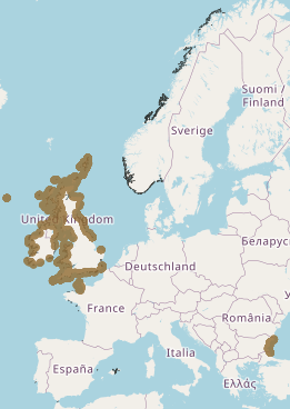
This layer shows the current known extent and distribution of Seagrass meadows in European waters, collated by EMODnet Seabed Habitats. The polygons portion was last updated in 2019. The points were added in Sept 2021. The purpose was to produce a data product that would provide the best compilation of evidence for the essential ocean variable (EOV) known as Seagrass cover and composition (sub-variable: Areal extent of seagrass meadows), as defined by the Global Ocean Observing System (GOOS). Seagrasses provide essential habitat and nursery areas for many marine fauna. There are approximately 72 seagrass species that belong to four major groups: Zosteraceae, Hydrocharitaceae, Posidoniaceae and Cymodoceaceae. Zostera beds and Cymodecea meadows are named on the OSPAR Threatened or Declining Habitats list. Posidonia beds are protected under Annex I of the EU Habitats Directive. This data product should be considered a work in progress and is not an official product.
-
EMODnet Biology provides three keys services and products to users. 1)The data download toolbox allows users to explore available datasets searching by source, geographical area, and/or time period. Datasets can be narrowed down using a taxonomic criteria, whether by species group (e.g. benthos, fish, algae, pigments) or by both scientific and common name. 2) The data catalogue is the easiest way to access nearly 1000 datasets available through EMODnet Biology. Datasets can be filtered by multiple parameters via the advanced search from taxon, to institute, to geographic region. Each of the resulting datasets then links to a detailed fact sheet containing a link to original data provider, recommended citation, policy and other relevant information. Data Products - EMODnet Biology combines different data from datasets with overlapping geographic scope and produces dynamic maps of selected species abundance. The first products are already available and they focus on species whose data records are most complete and span for a longer term.
-
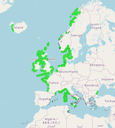
This layer shows the current known extent and distribution of macroalgal canopy in European waters, collated by EMODnet Seabed Habitats. The polygons portion was last updated in 2019. The points were added in Sept 2021. The purpose was to produce a data product that would provide the best compilation of evidence for the essential ocean variable (EOV) known as Macroalgal canopy cover and composition (sub-variable: Areal extent), as defined by the Global Ocean Observing System (GOOS). Kelp and fucoid brown algae are the dominant species that comprise macroalgal forests. This data product should be considered a work in progress and is not an official product.
-

This dataset shows the global distribution of seagrasses, and is composed of two subsets of point and polygon occurrence data. The data were compiled by UN Environment World Conservation Monitoring Centre in collaboration with many collaborators (e.g. Frederick Short of the University of New Hampshire), organisations (e.g. OSPAR), and projects (e.g. the European project Mediterranean Sensitive Habitats “Mediseh”), across the globe (full list available in accompanying metadata table within the dataset).